After the problems with reclaiming the area, the National Institute for Agrarian Reform took over the reclamation work in 1964 and completed it in 1970. The area is located at 907 metres above MSL (mean sea level) and is, as far as I know, the second highest polder on earth. The management of the polder was transferred in 1990 to, say, the ASORUT Water Authority.
Two of my Colombian students did research in this polder for their MSc thesis. I visited the relevant places with one of them in 2002. In itself, this was a special undertaking, due to the safety aspects in Colombia. It started upon arrival at the airport in Bogota. There was a traffic light system to determine which suitcases had to be checked by customs. In my case, the traffic light turned green, so I was allowed to continue. An uncle of my student was waiting for me in front of the airport with his car and took me to the hotel. The next morning the uncle brought me back to the airport where I would fly to Cali, where this polder is located. In Cali my student was waiting for me and together we visited the area. The return trip was organized in the same safe way.
Agriculture in the polder is characterized by two growing seasons that correspond to the two rainy seasons during the year. Land use in the polder changed considerably at the end of the last century, as farmers started growing crops that resulted in a better income. The main crops were soybean, cotton and sorghum. At the beginning of the present century, sugar cane was introduced on about a quarter of the polder.
A dike on the East side along the Cauca River and a diversion canal on the West side to divert water into the rivers from the mountain range enclose the area, while a main drainage canal through the lowest parts more or less divides the polder in two. The diversion canal not only protects the polder from flooding by the small rivers, it also supplies irrigation water to some parts of the polder. Users along the canal use small centrifugal pumps to pump irrigation water to their fields. The rest of the polder is supplied with water by an irrigation system consisting of a main canal, a transport canal and several secondary canals. The main canal is supplied with water by three pumping stations. Irrigation in the polder supplements rainfall. It is likely that more water is supplied than is needed, which not only leads to higher pumping costs for irrigation, but also for drainage.
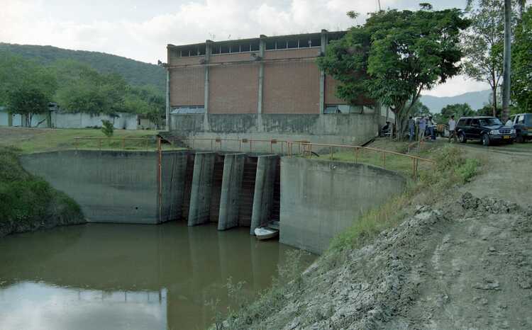
There is a complementary network of both irrigation and drainage canals at secondary and field level. The main drainage canal discharges during low water at the downstream end via a valve into the Cauca River. At high water in the river, the valve remains closed and the excess water is pumped out into the river by two pumping stations. The functioning of the drainage system depends on the rainfall pattern and the water levels in the Cauca River. Staff gauges monitor the levels in the main drainage canal. When the levels are too high, one or both drainage pumping stations are activated. These periods usually correspond with the rainy seasons, but also with the second month of the growing seasons, when too much irrigation water is let in.
All in all, a special area, not only because of the high location of the polder, but also because of the complete system of water management and protection against flooding.


