I became involved in this problem in various ways at the time, including in 2007 in a project financed by Dutch Development Cooperation to investigate whether the Banger region on the East side of Semarang could be turned into a polder. In 2015 I was involved in a partnership between Indonesia and the Netherlands to protect the old city of Semarang from flooding. In themselves these were fairly manageable problems, but a clear overview was lacking to take the necessary measures.
First, the Banger region. This area is located on the East side of Semarang and has had to deal with increasingly frequent flooding over the years. The question was what measures could be taken to improve the situation. On the Dutch side, input was provided by the consultant Witteveen + Bos for the polder design, the Water Authority Schieland and Krimpenerwaard for the institutional aspects and UNESCO-IHE for the drafting of Guidelines for the design, operation and maintenance of urban polders. On the Indonesian side, input was provided by the Ministry of Public Works, the city of Semarang and the Institute Pusair, a kind of Deltares for Indonesia. The various plans were developed in close cooperation.
The Banger region was in open connection with the sea through the Banger River, which runs through the middle of the area. As a result, the area not only had to deal with precipitation and river water, but also with incoming seawater during high tide. A closed dike had to be built around the area, which would turn Banger into a polder. We initially thought that a discharge sluice, through which excess water could be discharged to the sea at low tide, would be sufficient for the first period. However, the subsidence was so rapid that it was decided to immediately build a pumping station. However, due to all kinds of problems, it took a number of years before the pumping station was actually built and the polder was fully completed.
As mentioned, in 2015 I became involved in the problem of regular flooding of the old city of Semarang. Here too, the problems increased due to the subsidence. We visited the various important locations. It turned out that the situation had actually improved considerably due to a number of works that had already been completed and the old city was now already in a polder. Floods were caused by extreme rainfall, but also by the inflow of water from the neighbouring Banger region. The dike in the Banger region had not yet been closed, so that during high tide the water could flow into the old city. On the other side, the old city is bordered by the Semarang River, which flows more or less through the middle of the city of Semarang. Excess water could be drained from the old city to the Semarang River in two ways. There was a discharge sluice and during high tide in the river the excess water could be pumped out by a pumping station.
Finally, around 2013, the mouth of the Semarang River to the sea was closed off by a dike and a discharge sluice and a large pumping station were built to drain excess water to the sea. In itself, the situation on that side of the old city was actually quite good.
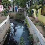
However, a problem was that the canals in the old city were not properly maintained, which caused various obstacles and hindered proper drainage. If these canals were better maintained and the Banger Polder dike and the pumping station were ready, which is now the case, the situation would have improved considerably. In the middle of the old city was a large pond, which also played an important role in the storage of water. There were plans to raise at least a significant part of this pond in order to build on it. We strongly advised against that at the time. Later, our Indonesian contact told us with some pride that they had managed to preserve the pond. Let's hope that maintenance continues to be taken seriously and that the pond is preserved, because Semarang has a beautiful old city.


