Two discharge sluices had been built in the sea dike. Although the inner dikes had not yet been constructed, 3,500 hectares, located in the higher areas, were already in use for growing rice. Construction of the sea dike had been started for a second area. Several smaller projects had also already been started.
In the framework of the realisation of the programme, the government had contacted the United Nations Development Programme (UNDP) and the Food and Agriculture Organisation of the United Nations (FAO). The FAO had in turn contacted the former IJsselmeerpolders Development Authority (RIJP), which had led to an agreement for assistance. Employees of the former Service for the Zuiderzee Projects (ZZW) and Delta Service of Rijkswaterstaat were also involved in this. The main objective of the project was to assist the government, in particular by cooperation in the design of a 30 kilometres long model dike and in the development of a model agricultural polder.
In the framework of the project, in the period 1987-1989, several employees of the aforementioned Services visited North Korea and a group of North Korean specialists visited the Netherlands. This were not easy undertakings, because to visit North Korea we first had to fly to Rome to obtain information from the FAO and a visa for North Korea. At that time, the Netherlands did not yet recognise North Korea. Then we had to fly to Beijing, from where we could eventually fly to Pyongyang in North Korea. The North Koreans first had to go to Moscow to obtain a visa for the Netherlands and could then continue to Schiphol.
The areas of the project were not far from the border with China. To visit these areas we went by train, which was a journey of about four and a half hours. Locally we were then taken by vans and boats to the locations of interest. We were always accompanied by our guide, a few specialists and an interpreter. On site we were guided by local contacts. Given the special situation of North Korea, everything went quite well.
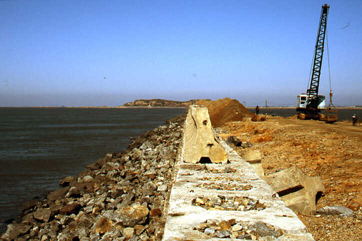
At the areas that we visited the tide in the Yellow Sea was about eight metres, which made the construction and closing of a sea dike rather complicated. As the closing gap becomes narrower, enormous current velocities occur. When designing the model dike, the condition of the material with which the dike would be built, the depth and condition of the subsoil, the course of the tide, the expected water levels during storms and the height of the waves had to be taken into account. The most important components of the design were the location and profile of the dike and the method of closing. When determining the height and profile of the dike, the protection of the slope, the expected rise in sea level and the subsidence during the lifespan also had to be taken into account.
At the start of the project, data on the dike design were available to a limited extent. With the equipment that was purchased in the Netherlands during the project, and transported to North Korea by the Trans-Siberian Railway, among other things, valuable additional information for the dike design could be obtained. The design of the model sea dike was discussed extensively. The proposed route between the connections to the coast ran via six islands. After the dike construction, the area would consist of 23,300 hectares of land, located above 4 metres below sea level and an inland lake of 10,200 hectares. The intention was to start construction in 1989. The closing gaps of the various dike sections would be closed with caissons. The dike construction material would be transported by ship over sea and transported further over the completed part of the dike by truck. A number of problems arose during the development of the construction and the execution. In order to solve these problems, various computer programs were available in the Netherlands, which were applied to the local conditions.
In addition to the sea dike, inner dikes had to be constructed to protect the polders from flooding by the inland lake. The management of the water level in the inland lake had to be optimal for irrigation and drainage from the polders and the hinterland, and to minimize damage to crops due to the salinity.
In the development of the model polder, various aspects were important. These included the structure and design of the irrigation and drainage systems, the location and design of the pumping stations, protection of the banks of the main canals, measures to improve the soil and the exploitation, maintenance and management of the agricultural lands, measures to prevent damage to crops due to salinity and to promote the desalination process, as well as the road system.
While the realization of the Taegye do model polder was in full swing at that time, the various aspects concerning the exploitation and development of this area were discussed. The irrigation system consisted of an inlet sluice or pumping station, primary irrigation canal, secondary irrigation canals and field irrigation canals. The drainage system consisted of field drains, secondary drainage canals, primary drainage canals and drainage sluices or pumping stations. For the rice fields, it was assumed that the rice could be submerged for two-thirds of its length for a short period. The proposed layout of the polder included a basic plot of 50 x 125 metres and a basic block of 500 x 500 metres, which seemed a logical arrangement in itself. In connection with the cultivation of rice, it was necessary to level the plots and it was assumed that the difference in level between adjacent plots could not exceed 0.30 metres.
In order to pump out the excess water, twelve pumping stations were originally considered. In the areas above mean sea level, these pumping stations would be combined with discharge sluices to drain the excess water to the inland lake. The Service responsible for the design and management of the polder was planning to reduce the number of pumping stations to three. The pumping height would vary from three to six metres, depending on the surface area and the water level in the inland lake. The pumping capacity of the pumping stations had yet to be determined. Two types of roads were distinguished: main roads and field roads. No people would live in the polder, this implied that good connections to the old land were necessary in the area around it. All roads in the plan were therefore connected to the old land. The design criteria used for the various systems were generally suitable for the conditions in North Korea, provided that the systems were well maintained. Given the maintenance of the existing agricultural land, it could be expected that the newly developed areas would also be well maintained.
A large part of the area to be developed was relatively low. In principle, this area could be drained by the pumping stations. Nevertheless, measures had to be taken to prevent saline seepage. The possibility of desalination of the saline soils depended largely on the availability of fresh water and the nature of the soil. Seepage through the sea dike could also be a problem. The soil of the Taegye do area consisted of an impermeable rock in the subsoil covered with a permeable sand layer and a poorly permeable clay layer. The seepage through the sea dike was calculated for various levels of the water in the inland lake.
Pumping stations for drainage are normally expensive elements in the water management of polder areas. The level of the soil in the Taegye do area was such that with good management of the water level in the inland lake, a considerable part of the water, for example from the area above mean sea level, could be drained through discharge sluices.
The design of the Taegye do model polder was discussed extensively. In view of the above, the water level in the inland lake became the main point of discussion. It was finally determined that under average weather conditions, the water level in the inland lake could best be kept at a level of 1.5 metres below sea level.
As mentioned, for the realisation of the polders, both a sea dike and inner dikes had to be constructed, with an irrigation and drainage system in the polders. This made the projects very expensive. That is why we ultimately proposed as an alternative approach to first reclaim only the higher parts of the area. This could be done in a relatively simple way with a relatively small sea dike and without inner dikes. Because the silting up from the Yellow Sea is very fast, the lower parts that had been raised by silting up could then also be reclaimed step by step. An interesting point here was that at that time a number of similar projects were being realised in South Korea. In South Korea, land prices are very high, so that the costs for the expensive land reclamation with sea dikes and inner dikes could be recovered in the long-term. North Korea is a communist country where the land belongs to the State. In such a case, the high costs for the expensive land reclamation cannot actually be recovered.
All in all, this was an interesting project for the employees involved, both technically and because of the special circumstances in North Korea. A look at Google Earth now shows that a number of coastal polders have indeed been constructed since then, but not nearly as many as were planned at the time. Full realization would also have been a very expensive undertaking.